Thar Might Be Dragons... Or Thar Might Be Nothing At All
The recent “disappearance” of Sandy Island — a long-mapped island in the South Pacific that appears to have never existed — was a fresh reminder that, even with the most modern, state-of-the art, satellites-and-all technology at our disposal, we still may not actually know where everything is. Frankly, we never have — and we’ve made some pretty awful guesses over the years.
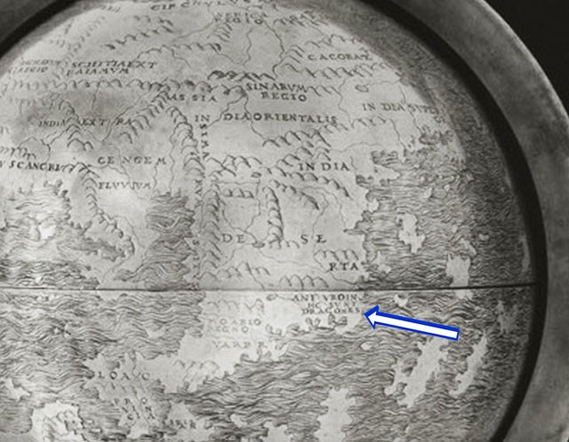
Though it’s probably one of the most well-known cartography-related phrases, “Thar Be Dragons” has, as far as we know, only appeared on a single map. That map is the Hunt-Lenox Globe, currently in the New York Public Library’s collection. The globe’s origins are mysterious; no one knows where it came from or who designed it. (It’s named after architect Richard Morris Hunt and collector James Lenox, whose private library was incorporated into the NYPL.) And the warning might not even be about dragons! The map’s in Latin, and HIC SUNT DRACONES could just as easily be referring to the Dagroians, a people described by Marco Polo in the account of his travels. Polo mentions the Dagroians as a tribe in southeast Asia who eat their dead. However, this tribe (not unlike dragons themselves) may not have existed.
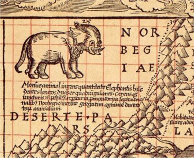
Whether it was indicating dragons or cannibals, the message is clear: stay away. There are other things to be scared of out there, too. Many early cartographers warned of lions — HIC SUNT LEONES — in unknown places. Looked at from the mapmaker’s point of view, it was worth winging a guess on: if there aren’t lions there, great! If there are lions, well, can’t say you weren’t warned. And many fearsome creatures warned of on maps did, in fact, exist. Martin Waldseemüller, one of the first cartographers to call the new world “America,” told of a terrifying creature in northernmost Norway, an elephantine beast with two long teeth. The monster in question? A walrus. The image at top is his rendering.
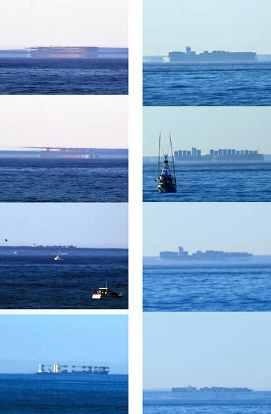
What if the place being mapped never existed in the first place? During an exploration of the Antarctic Ocean, a large landmass was sighted by Captain Benjamin Morrell, an American, who claimed it to be New South Greenland and set about recording the features of, but not setting foot upon — the island. He provided precise coordinates and detailed descriptions, however, and New South Greenland existed right up until someone else tried to find it. Whoops! Basically, everyone who tried to find New South Greenland denounced Morrell as a storyteller and/or drunk based not only on his totally not real island sighting, but also because he claimed to have covered a totally unreasonable amount of water in a short period of time and because some of the more plausible sections of his post-voyage write-up bore a suspicious resemblance to explorer James Weddell’s, published five years earlier. However, there are a couple other reasonable explanations for what may have happened. The first is that Morrell bungled the coordinates and actually saw part of the Antarctic Peninsula. His descriptions of the island are similar to features founds on the peninsula’s Foyn Coast.* The second is, in my non-official opinion, more likely. Have you ever been driving on a really hot day and thought for a second you saw weird shiny puddles on the pavement? That’s a type of mirage induced by air being hotter closer to the pavement, which refracts the light downwards. This is what Morrell could have seen, but in reverse. When the air near the ground is much cooler than the air immediately above, it refracts the light upwards, showing things that are not there. It’s complicated to explain, so here is a pretty helpful Wikipedia page on the concept.
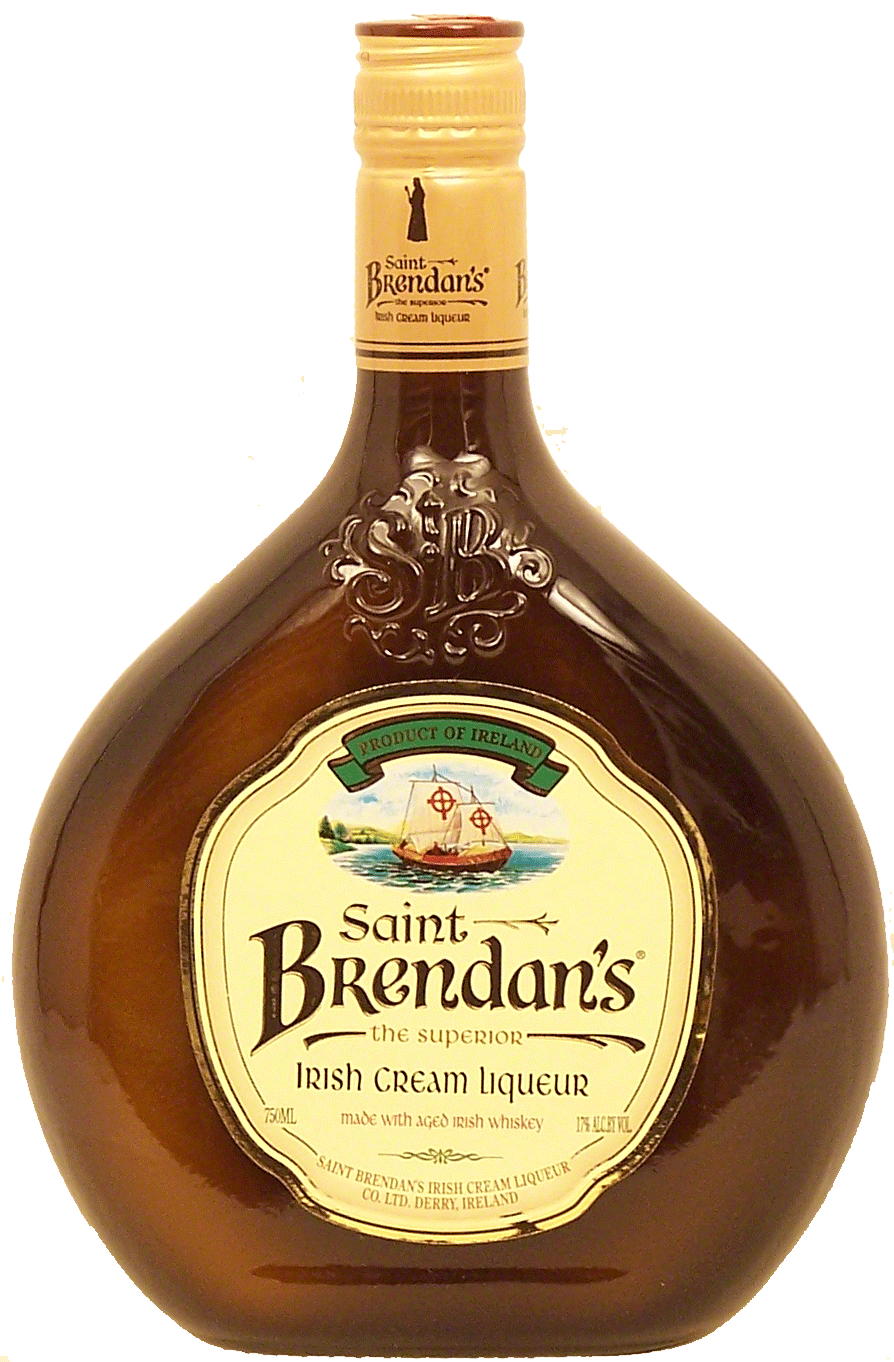
In other cases, the place actually does exist, and a good way to become associated with it is to star in your very own wild religious pilgrimage. St. Brendan is known as “St. Brendan the Navigator” due to the historic Odyssey-esque journey he is fabled to have taken, a seven-year-long around 512 A.D. from his native Ireland to seek paradise. Brendan and his crew, instead of reaching the Garden of Eden, supposedly found a lush land (later billed as Saint Brendan’s Island) where the sun never set, the birds sang without ceasing, and other implausibilities. Also, on his way back to Ireland, they alighted upon another small island. The crew disembarked, celebrated mass, and set up a campfire for the evening. No sooner did they light the fire, however, that the island began to move and shake — the ship had landed not on an island, but on a giant sea monster. Yikes! Anyway, the non-monster island loomed large in Irish seafaring legend, even appearing on maps labeled as “The Fabled Island of Saint Brendan.” It has remained in the realm of fantasy for centuries, but as it turns out it may not have been pure fable. In the 70s, British explorer Tim Severin recreated the journey (500 A.D. era ships and all) and it was discovered to be… completely possible that Brendan and his crew may have actually gone on the voyage and landed on the 100% real coast of Newfoundland (its neverending birdsong remains to be proven). Today Saint Brendan is memorialized in a rather Irish Catholic way… he has his own cream liqueur. It’s even got a little boat on the label! Oh, and a note about Tim Severin: guy recreates famous historical voyages for a living. Best job ever? Best job ever.
Other times, the non-existence of a mapped place was a totally intentional “mistake” — sometimes with far-reaching consequences. Exploration was an expensive undertaking, and one way to keep your patron’s purse strings loose was to name every freaking thing you saw after them.** Some French explorers, names lost to history, claimed a pair of islands in Lake Superior for France and christened them Île Philippaux and Isle Pontchartrain, after Louis Phillippaux, comte de Ponchartrain, a government minister who must’ve had the power to authorize the expenditure of huge amounts of francs. The islands were charted and began to appear on other maps. You can guess where this is going: they never existed, it was purely a ploy for cash. The lie escaped notice for years, and the island even appeared on the Mitchell Map in the 1750s. John Mitchell, a botanist living in colonial America, was charged with the task of creating a detailed map of the North American colonies by the British government. Having heretofore only made maps as a hobby, Mitchell drew upon whatever maps he could find as sources, including ones created by French geographers, who would have included the Philippaux and Ponchartrain on their documents. The Mitchell Map, though not perfect, and strongly biased towards British interests, was the most accurate map available for decades — right up through the end of the Revolutionary War. It was used at the 1783 Treaty of Paris peace conference to demarcate the fledgling United States’ border from the still-British Canada. That border was drawn straight through Lake Superior using… you guessed it… Ile Philippaux as a guide point. But the ruse wasn’t discovered until 37 years later, when other Mitchell Map-based discrepancies on the Maine border forced the entire border to be properly surveyed. It was only then that Ile Philipaux and its sibling, Isle Ponchartrain, were discovered to be wholly phantom.
* Named for Norway’s Svend Foyn, inventor of the “grenade harpoon.” Probably available from Skymall.
** Why do you think there are so many Victorias worldwide?
Related: How To Not Get Lost
Hic Sunt Victoriae. Waldseemüller map image courtesy of Fuck Yeah Maps; Hunt-Lenox globe map image courtesy of Silvana Silva Davila.