A Survey Of Moon Maps Since the 17th Century

How do you map something 238,856 miles away? You can’t just send out a team of surveyors. At least, you couldn’t until relatively recently. Before then, lunar cartographers (technically, selenographers) could only rely on telescopes and their own artistic ability to draw a detailed portrait of the lunar face. They managed some pretty dazzling results.
One of the first widely seen images of the moon (aside from the IRL version), the drawing at left was included by Galileo in a book published in 1610. While he didn’t technically map the moon, these observations were among the first to take note that the moon was not a perfect smooth magic sky-ball but a rough, irregularly surfaced rock with valleys and mountains and other chartable features.
1645 — VAN LANGREN

The first formal attempt at mapping the moon — that is, one that didn’t just take note of curious craters and riveting ridges, but attempted to define all features on a grid — happened only a few decades later, in 1645. Dutch astronomer Michael van Langren attempted a detailed study of the moon’s visible surface during different phases, undertaken as a way of determining longitude here on Earth. He gave up on this (incredibly unsuccessful) quest early, but not before naming many of the observed features. Most of his names were in honor of Catholic saints and church figures of the day, but he did manage to find a crater to call “Langrenus,” after himself. Hilariously, it is one of only a handful of his names that stuck — you can see it on the eastern edge of the Mare Fecunditatis.

(Map courtesy of Universiteitsbibliotheek, Leiden, via; Langrenus close-up via Wikipedia.)
1647 — HEVELIUS

Two years later, Van Langren’s Polish rival, Johannes Hevelius, published a more complete description of the moon (literally, it bears the title Selenography, or a Description of the Moon) in the form of a lunar atlas. The two years of extra effort was worth it: Hevelius is remembered as the father of lunar topography. This year marks the 400th anniversary of his birth; Poland is currently enjoying a year of exhibitions and tributes to Johannes Hevelius as part of Rok Jana Heweliusz, which you can read more about here (if you happen to know Polish or enjoy the Google Translate interface). His maps, of course, had completely different toponyms. Unlike Van Langren, he named lunar features after what terrestrial features he thought them to resemble. Like Van Lengren, only a scant few of his survive, including moontain (not the official term) ranges named after the Pyrenees, the Apennines and the Alps. The Moon Alps even have their own Moon Alpine Valley. (Image courtesy of the Library of Congress, via.)
1651 — RICCIOLI

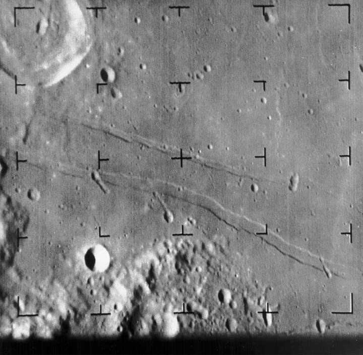
Enter priest Giovanni Riccioli. Not long after Van Lengren and Hevelius’ publications, Riccioli put out his own work. It didn’t really contain any actual new features, and it wasn’t really his work (it was drawn by Francesco Grimaldi), what makes it worth including here is his name scheme. All Latinized, the seas are named for various conditions generally attributed to the moon (tranquility, fertility, rain) and the lands for the opposites of those conditions (vivaciousness, sterility, heat). For individual craters, Riccioli divided the moon into a series of octants and grouped names by type regionally; for example, craters named after scholars are typically found all in the same general area. Most, but certainly not all, of his names are still in place today. Take a look at this picture, taken by Ranger 8 in 1965 about 4 minutes before it smashed into the surface — that’s the Sea of Tranquility, Mare Tranquillitatus, 314 years after it was christened by Riccoli.

(Riccioli map courtesy of Museo Galileo; Ranger 8 image courtesy of NASA.)
1679 — CASSINI

The 17th century was a great time to be alive if you were interested in staring at the moon — truth be told, moon maps were probably more accurate than earth maps at this point. Check out how much the art of seleography advanced between Galileo and Cassini, who published this map in 1679. Intrigued by an oddly shaped crater rim, he included a small drawing of a woman’s face in profile. Can you find Cassini’s ‘Moon Maiden’? Here’s a guide if you can’t. (Image via Museo Galileo.)
1748 — MAYER

Van Lengren may have been the first to use a grid for lunar cartography, but Tobias Mayer was the first to give the moon proper latitude and longitude and take libration into account. See, though the far side of the moon would not be visible until the Soviets sent a satellite around in the 1960s, slightly more than half of the moon is observed nightly. The moon is not just a flat circular disc but a round three-dimensional object being hit by light from a rotating Ear….oh here, just look at this animation. I can’t explain it any better. Anyway: Mayer used his libration calculations in order to produce a series of incredibly accurate maps of the surface of the moon during a lunar eclipse on August 8, 1748. All of that aside, it is one gorgeous piece of cartographic art. (Image courtesy of the Bibliothèque nationale de France.)
Let’s leap forward here, for the next big developments in lunar cartography didn’t happen for 200 years. However, don’t take this to mean there was a two-century gap in moon mapping, nor that the advances made in those years are forgettable. However, going through each minute tip-toe forward only to end with “and then we landed on it! Good night!” — this is not the hill I want to bore you on. The next major advancements in lunar cartography came during the mid-20th-century space race between the USSR and USA.
1959 — THE SOVIETS


The Soviets were up there first, in 1959, sending up Luna 1, the first man-made object to leave the Earth’s atmosphere and never return. Unfortunately, it missed its target, and accidentally became the first man-made object to orbit the Sun. The Soviets, never ones to miss an opportunity, rechristened Luna-1 as “Mechta” and declared the 800-pound sphere a new planet. Luna-2 succeeded in hitting the moon, and (as seen here) Luna-3 sent back the first images of the far side of the moon, something previously only wondered about. Surprise! No moon yeti on that side, either. (Frames 27 and 28 of Luna-3’s film courtesy of Mental Landscape.)
1966 — THE AMERICANS

Between 1966 and ’68, the Americans, feeling as though merely looking at the moon wasn’t enough (well, they felt a lot of things, but you know, Cold War), launched seven individual spacecraft — the Jet Propulsion Laboratory’s Surveyor program — to the surface of the moon to transmit photographs and soil data, with the goal of testing the feasibility of a manned landing. As the program discovered, and a fact of which you are probably aware: totally okay to land on the moon! No signs of Moon Yeti anywhere, even after pretty close investigation! Surveyor 3, which scouted the Mare Cogitum, was close enough to the Apollo 12 landing site that astronauts were able to amble over to it and remove parts; the camera, which sent back over 6,000 images of the surrounding area, is now on display at the Smithsonian Air & Space museum. The above image is from the last of the program, Surveyor 7. Close up panoramas like these were used by NASA for, among other things, judging ground quality. None of the Apollo missions came even close to the crater-filled area where Surveyor 7 touched down — too risky. (Image courtesy of NASA; others here.)
2010 — NASA

They’re still mapping the moon, by the way, even though there aren’t concrete plans to return. Clementine, launched in 1994, orbited the moon for two months and imaged every surface with a variety of instruments, including high resolution camera equipment and LIDAR. More recently, NASA sent up the Lunar Crater Obervation and and Sensing Satellite, or LCROSS, to smash into the moon’s south polar area and observe the dust plume resulting from the collision, a low cost way to check for polar ice, hydrocarbons, or other hydrated materials. And just last year, NASA embarked upon an unprecedented mission: a 100% complete map of the moon. Previous mapping efforts have only included the parts we can see, but the Lunar Reconnaissance Orbiter, launched at the same time as LCROSS, is already providing GPS-quality topographical data for regions of the moon that Johann Hevelius and his contemporaries only dreamed about. NASA has put out a video displaying some of the LRO’s truly stunning accomplishments so far. The mission was a success as well: the moon has water! It’s in the form of ice at the southern pole. (Image courtesy of NASA/GSFC/MIT/SVS.)
MOON CRASHES!
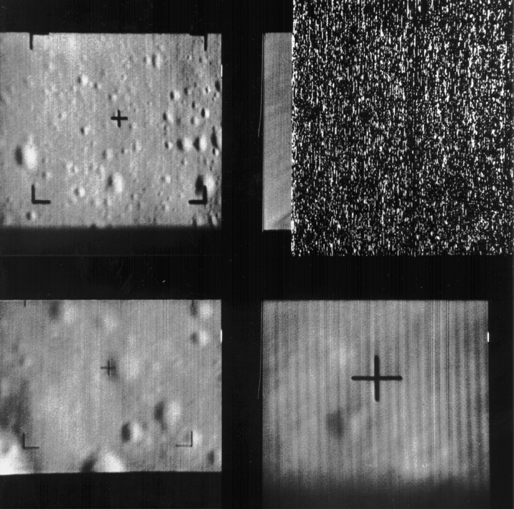
The moon’s seas aren’t filled with water, but you know what you will find in the seas? And also in craters, on ridges, and, basically, anywhere? Remnants of things that have crashed into the moon! Not all of these were as intentional as LCROSS, either. Among manmade debris like the Lunar Rover lie dozens of busted lunar projects. Like most, the American series of launches known as the Ranger project transmitted images back to Earth up to tenths of a second before impact. Here are a few of the last things they recorded.

Ranger 7’s final image, July 31 1964. These images are incomplete — the static shows where the transmission ended. (Courtesy of NASA; via Wikimedia.)

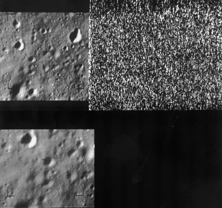
Ranger 8’s final image, a half-second before impact on February 20, 1965. (Courtesy of NASA.)

Ranger 9’s final image, tenths of a second before impact on March 24, 1965. (Courtesy of NASA.)
Victoria Johnson is a cartographer and this is her Tumblr. She wishes you a happy Geography Awareness Week!