Name That Los Angeles Neighborhood!
Name That Los Angeles Neighborhood!
by Eric Spiegelman
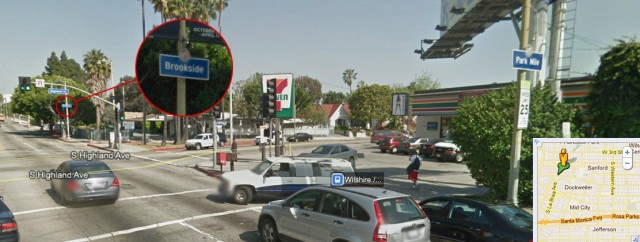
You’re standing at the intersection of Wilshire and Highland. What neighborhood are you in? The sign on the corner says you’re somewhere called Brookside. The sign on the other corner says you’re in Park Mile. The sign a block away, in full view of the other signs, says you’re in Sycamore Square.
Google Maps doesn’t mention any of these. Google Maps calls this neighborhood Dockweiler. Where it gets this from, I have no idea. Los Angeles does have a Dockweiler — but it’s Dockweiler State Beach, 15 miles away, by the airport. Google Maps calls the adjoining neighborhood Sanford. But that’s Koreatown. Google Maps is just making stuff up.
Talk to someone who lives around here and the picture won’t get any clearer. One person will say the intersection is part of the Miracle Mile, which it kind of is. Mid-Wilshire is also semi-accurate. Someone else will say it’s Hancock Park, which it isn’t, but it’s close enough, and Angelenos have a gentlemen’s agreement to let people say they live in a neighborhood when really they live right next to it.
Consider the three Carthays, which lie a mile to the west: Carthay Square, Carthay Circle and South Carthay. Real-estate agents call this area ‘Beverly Hills Adjacent.’ This is geographically accurate; the Carthays are indeed right next to Beverly Hills. But Beverly Hills has higher property values, its own school district and its own police force. The Carthays have houses with bars on all the windows. If someone tells you they live Beverly Hills Adjacent, they’re selling something.
People who live along the eastern edge of East Hollywood will sometimes fudge their way into Los Feliz. There’s a section of Los Feliz where it’s popular to consider yourself part of Silver Lake. Hipsters who think Silver Lake has become too gentrified claim the disputed border between the two for Echo Park. Locals who don’t care refer to that border as HaFo SaFo, after the Happy Foot Sad Foot sign at Sunset and Benton. A friend of mine insists he coined this but I’m skeptical. The city’s official name for it is Berkeley Hills. Nobody calls it that.
Locals divide Sherman Oaks into South of the Boulevard and North of the Boulevard, the boulevard being Ventura Boulevard, the subtext being that one side is much wealthier than the other. Franklin Hills carved itself out of Los Feliz some time ago and maintains they were never a part of that other neighborhood to begin with. They’re so adamant about it that everyone’s like, fine, go be Franklin Hills. Windsor Square refuses to believe it’s part of Hancock Park. Google Maps calls that area Oakwood. Again, not a thing.
There’s a neighborhood called West Los Angeles. West Los Angeles is not to be mixed up with the Westside of Los Angeles, which includes everything west of Hollywood, including West Hollywood, which isn’t part of Hollywood because Hollywood is part of Los Angeles and West Hollywood is its own city. There are a good two miles of Los Angeles to the west of West Los Angeles. There’s a major street called Western that’s on the Eastside of Los Angeles, which you should never confuse with East Los Angeles, because East Los Angeles is also a separate city, to the east of Downtown Los Angeles.
Los Angeles has a Chinatown, a Thai Town, a Little Tokyo, a Little Ethiopia and a Little Bangladesh. Google Maps only shows Little Armenia. A couple years ago the city named one area Historic Filipinotown, even though it hasn’t been a Filipino neighborhood in fifty years. Hence the “historic” designation. Other areas are also named for things that no longer exist. The locals call Elysian Valley ‘Frogtown’ because their lawns used to fill with frogs before the river was lined with concrete. Then there’s Historic Downtown, which is different from the Historic Core that happens to be Downtown, and an Old Bank District. Historic West Adams, however, is the same thing as West Adams.
“What part of Los Angeles do you live in?” is not always an easy question. There are the 30 or so neighborhoods that used to be listed in the back of the Thomas guide, a map book that every Angeleno kept in their car before there was Internet. There are the 87 recognized by the Los Angeles Times in its Mapping L.A. project from a few years ago. At least half of those have disputed boundaries. There are the hundreds of sub-neighborhoods the city keeps trying to formalize with little blue signs. These are often dubious. There is the handful of unofficial neighborhoods named spontaneously by the people who live in them. And then there are the ones recognized by Google Maps, which have little foundation in reality.
So back to the corner of Wilshire and Highland. A friend of mine used to call that area ‘Trader Joe’s Adjacent.’ Which kind of stuck, though I think that neighborhood should really end a block to the north.
Eric Spiegelman is a proprietor of Old Jews Telling Jokes.